Milkweed for Monarchs
This project determines optimal locations to plant several species of milkweed in Humboldt County in order to help and provide more habitat for monarch butterflies. Milkweed (members of the genus Asclepias) is crucial for the survival of monarchs. For breeding, the monarch depends on its host plant, milkweed. The adult butterflies also lay their eggs on the underside of milkweed leaves, and when the caterpillars hatch they use the plant for food. Consuming milkweed also makes the caterpillars toxic, a defense mechanism against predation. The population of monarchs has experienced a dramatic decline in recent decades. This is due to factors such as habitat destruction and seasonal variation caused by climate change. This is why it's vital that more habitat is provided for them so that they can re-establish their population.
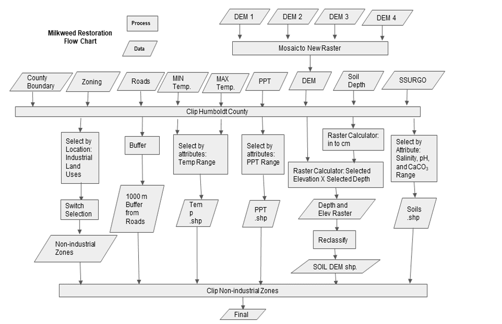
Methodology
Datasets from USGS National Map, the USDA, NOAA, and Humboldt County GIS were used. Shapefiles for the Humboldt County boundary, roads, zoning, salinity, pH, precipitation, a maximum temperature and minimum temperature, calcium carbonate, soil depth, and a digital elevation model (DEM) were used for analysis. Each dataset was defined and/or projected into NAD83 UTM Zone 10N, except the soil layer which required manipulation before this was possible. For the soil dataset, the desired soil properties were selected (Table 1) from the SSURGO database then selected by attribute the desired pH, calcium carbonate (CaCO3), and salinity range from the table. Using the built-in relationships between tables in the database, the related polygons were selected and exported. This file was then projected into NAD83 UTM Zone 10N. Four raster datasets were downloaded to encompass the entirety of Humboldt County, so the mosaic to new raster tool was used to stitch the four layers together. All the the layers were then clipped to the Humboldt County boundary. Then the raster calculator was used to determine which areas of the DEM were within the species' tolerance ranges, and then to determine which areas had a soil depth greater than the minimum soil depth. These elevation and soil depth layers created were then multiplied together to determine overlap, and the resulting layer was exported. The precipitation and minimum and maximum temperature were selected at the specified ranges and were exported. A buffer of 1,000 meters was made around roads to ensure accessibility of planting areas. Then, using select by attribute with the zoning shapefile, industrial areas were excluded. Lastly, these non-industrial zones were clipped to the extent of the soil properties, elevation depth, precipitation, and roads buffer. These steps were repeated in accordance to each species’ specifications for ideal habitat.
Unfortunately, the decline of milkweed due to agricultural pesticides and changing land use has impacted monarch butterflies (Flockhart et al., 2014). Planting more milkweed, specifically ones that are native, is a viable approach to mitigate the decline in population of monarchs.
Four species are native to Humboldt County: narrow-leaf milkweed (A. fascicularis), showy milkweed (A. speciosa), purple milkweed (A. cordifolia), and woollypod milkweed (A. eriocarpa).


Species tolerances to elevation, climatic conditions, and soil properties used as parameters in GIS analysis
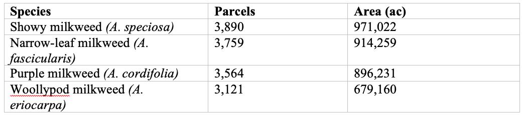
Area of potential planting sites
Conclusion
The results indicate a significant portion of land that could be used to create more monarch butterfly habitat by planting milkweed in Humboldt County. Our analysis was based on the specifications of milkweed habitat and distance to roads to ensure accessibility. It is also possible that there was more area that could be a potential milkweed planting zone in this county. However, the soil datasets had some areas that did not have data so we were unable to determine if these areas would be viable. In terms of possible expansion of this project, further reports could locate schools or other community centers that are within these areas and communicate with them to make them aware they could successfully plant a milkweed garden and help to establish more monarch butterfly habitat. Further research in other areas on the monarch butterfly migratory route could help establish habitat along their entire journey. Community groups and private landowners can use these maps to determine appropriate milkweed species and plan plantings. Our maps will hopefully be used to make a physical change providing habitat for the monarch butterfly. It would also be an interesting project to use GIS analysis to investigate the effects of non-native milkweed, which blooms all year as opposed to just in the spring and is the preferred ornamental milkweed species in gardens, has on monarch butterflies. This is considered in part the cause for their population decline, and spatial analysis tools could be used to determine if it is or not.
Acknowledgments
Authors of this project include: Claire Wilhelm-Safian, Luis Melendez, and Isabella Norton.
Precipitation and temperature datasets were retrieved from the USDA NRCS Geospatial Data Gateway. The county boundary, roads, and zoning datasets are courtesy of Humboldt County’s GIS Data Download page. The USGS National Map Viewer provided DEMs. The soil depth raster was created by the Conservation Biology Institute and retrieved from DataBasin.org. Other soils data came from the Soil Survey Geographic Database (SSURGO) via USDA NRCS. Finally, the dataset of the surrounding counties is courtesy of the California GeoPortal.
